Know the Facts: I-30
Know the facts about the proposed enhancements to one of the most traveled roads in Arkansas.
I-30: Pulaski County > Know the Facts
There's been a lot of interest in the 30 Crossing project. Click on a question below to learn more. Can't find what you're looking for? Contact us and let us know how we can help.
Facts last updated on March 9, 2018
- Downtown Impacts
- Commute Impacts
- Safety and Congestion
-
If vehicle miles traveled (VMT) declines, will I-30 still require increased capacity?
-
If through traffic was diverted to I-440, could I-30 be converted into a boulevard?
-
Have other studies been conducted regarding the need for widening I-30?
-
Will the new proposed Arkansas River Bridge be one of the widest in the nation?
- Public Involvement
- Funding
- Schedule
- Transit
1. Downtown Impacts
1.1. Will widening the interstate necessitate additional highway widening, urban sprawl, and inner city job loss?
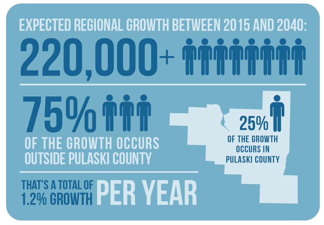
The need to widen I-30 and I-40 is a direct result of current and forecasted population increases in the Little Rock and North Little Rock regions. According to Metroplan, the region is expected to grow by more than 220,000 people between 2015 and 2040, with 75% of that growth occurring outside of Pulaski County. That translates to approximately 1.2% annual growth per year. Severe congestion on I-30 near downtown Little Rock and long commutes to the Central Business District could incentivize businesses to move out of downtown and to the suburbs. In addition, Metroplan’s System Analysis congestion charts and maps do not show that the widening of the 30 Crossing corridor has a negative impact on the regional system. The improvements are not just for added capacity, but also to address the complex merging and weaving of the numerous interchanges in the corridor which is a direct result of the existing infrastructure issues that the project is striving to resolve.
1.2. Has ArDOT considered sustainability, green development, communities, health and alternate transportation on this project?
ArDOT’s Planning and Environmental Linkages (PEL) report is a multimodal report and addresses sustainability, green development, communities, health and alternative transportation. The report makes recommendations for transit, bicycle, and pedestrian facilities. This report is available here for download and review.
1.3. Is the impact to the quality of life for adjacent neighborhoods being considered, such as improvements for pedestrian, bicycle, and transit access?
ArDOT is a proponent of multimodal transportation and a vibrant downtown for both Little Rock and North Little Rock. As part of the 30 Crossing planning process, the Department has been regularly meeting with city representatives and transit agencies to make sure the corridor is built to accommodate their future plans. However, as the state’s department of transportation, ArDOT has the responsibility to take into account everyone’s needs and compromise to do what’s best for the entire region and state. This includes the existing users of the roadway in addition to bicycle, pedestrian and other types of mobility. According to Metroplan, the Little Rock metro area is expected to increase another 220,000 people by 2040, with 75% of the growth expected outside of Pulaski County. There is an obvious need to continue to provide a safe way for drivers to access downtown. Pedestrian, bicycle routes and transit are included in the PEL recommendations and are being evaluated further in the National Environmental Policy Act (NEPA) study.
1.4. Would converting I-30 to a boulevard improve traffic flow downtown and be more pedestrian and bicycle friendly?
Based on Metroplan’s analysis of the boulevard alternative, the boulevard lacks sufficient capacity to accommodate current and future traffic, resulting in worse delays than are currently experienced in the corridor. A six lane boulevard can carry approximately half of a six lane freeway in vehicles per day. Currently, I-30 carries approximately 120,000* vehicles per day at the River crossing. Therefore, more than 45,000 vehicles per day would need to find alternative, less desirable routes in the region to downtown Little Rock and North Little Rock. The impact of a boulevard goes beyond just the mainline capacity. Impacts to other regional roadways as a result of excess traffic not accommodated by the boulevard, would necessitate improvements. Improvements would be needed to other local and regional roadways in the metropolitan area (e.g. I-430, I-630 and other local roads) to handle the increased traffic. In regard to improved mobility and safety for other modes of transportation (pedestrian, bicycle, and transit), the boulevard is expected to have a have a negative impact on these modes of
transportation. While the Department’s proposed alternatives would keep pedestrians and bicyclists separated from the main I-30 traffic flow, the boulevard would place these users directly in conflict with vehicular traffic. To protect pedestrians and bicyclists from this at-grade conflict across a 6-lane boulevard, lengthy pedestrian traffic signal phases would have to be added to the traffic lights. This would result in greater congestion to motorists and transit users, not only in the corridor but also in the downtown grid. Pedestrians crossing will be less desirable as a result of the risk of crossing the at-grade intersections and the wait time associated with the traffic signal timing. As a result, pedestrians are likely to cross at mid-block locations that are not intended for pedestrian crossing, increase the likelihood of an accident. Adding dedicated transit lanes will also complicate the signal phasing and cause further delay on the corridor for both vehicles and pedestrians.
Due to the size, complexity, and importance of this corridor, a large amount of funding has been set aside to improve the current and anticipated issues of the corridor. The Department has an obligation to the tax payers of the state to make sure any scenario considered to improve the corridor is validated through engineering analysis to ensure a benefit is provided to all users of the facility. Although a boulevard could provide aesthetic benefits to the corridor, it would make the safety and mobility of the corridor much worse.
*ArDOT 2015 Traffic Count Data
1.5. Is the 30 Crossing project similar to other highway decommissioning projects around the country?
Members of the public and various newspaper articles have referenced examples of other cities converting interstate highways and freeways into surface boulevards or eliminating the facilities all together. The 30 Crossing project team has prepared a Freeway Decommissioning report that reviews these referenced highway decommissioning projects in other cities and compares them to the 30 Crossing project in Little Rock, Arkansas.
Decommissioned highways can be an effective way to improve local access and mobility within a downtown city, add green space to a city, and ultimately rejuvenate a downtown. Decommissioned highways are effective in certain circumstances. Decommissioned freeways were found to be successful in cases of low traffic volumes, low through vehicles, lack of need for the route, other high-speed routes have taken place of the route, or the facility is a short-distance route (approximately 1-mile).
These 'characteristics of success' are not present in the 30 Crossing project area. The examples and projects described within the report fundamentally differ from the 30 Crossing scenario in Little Rock, Arkansas.
2. Commute Impacts
2.1. What are the future impacts for commuters to and from Little Rock and North Little Rock if we do nothing? (No-Build Option)?
I-30 and I-40 within Little Rock and North Little Rock are some of the most congested corridors in Arkansas. If the corridor is not widened, congestion will only get worse. Here’s why:
More Cars Using the Corridor: According to Metroplan, the population in Little Rock is expected to increase 220,000 by 2040, resulting in more cars utilizing the I-30/I-40 corridor. To forecast the increased traffic on the corridor, the I-30 study team worked with Metroplan and its CARTS travel demand model*, ArDOT historical counts, previous studies, and assumptions outlined in the I-30 Planning and Environmental Linkages (PEL) report to develop the 2041 future average daily traffic (ADT) volumes shown in the table below. The study found that ADT in the corridor is estimated to increase approximately 20% - 25% by 2041.
*CARTS travel demand model is jointly developed and maintained by ArDOT and Metroplan.
| Location | Existing ADT (2014) | Future ADT (2041) | ADT Increase |
|---|---|---|---|
Interstate 40, west of North Hills Blvd. |
124,000 |
158,000 |
34,000 |
Interstate 30 on the Arkansas River Bridge |
126,000 |
145,000 |
19,000 |
Interstate 30, south of Roosevelt Rd. |
97,500 |
122,000 |
24,500 |
Source: I-30 PEL |
|||
Congestion Increases: Based on the Future 2041 "No-Action" traffic modeling data, bottlenecks and congestion continue to increase during morning and evening peak hours. Peak direction travel speeds are anticipated to decrease to 20-30 mph resulting in corridor-wide travel time increasing to 16-18 minutes (nearly three times that of free flow conditions). As an example, morning inbound traffic moving west/south from U.S. Highway 67 to the I-30 River Bridge will face speeds dropping as low as 10-20 mph for approximately 90 minutes beginning around 7 a.m.
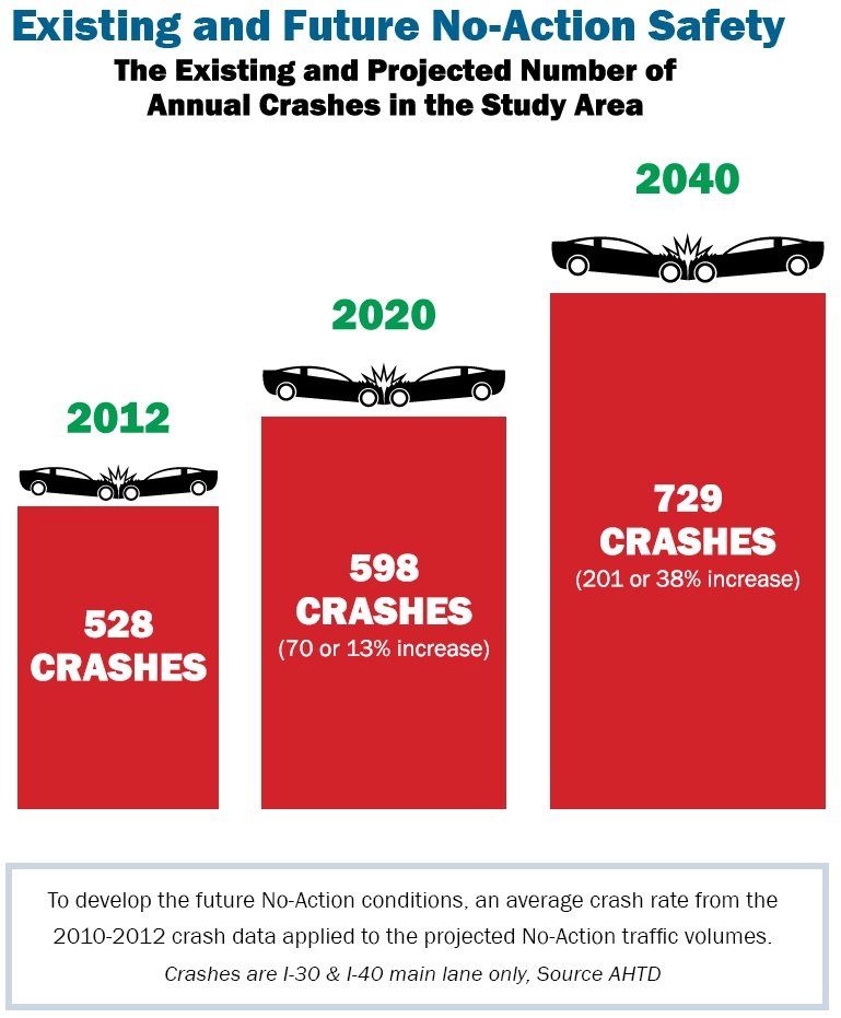
Crash Rates Increase: In 2012, there were 528 crashes along I-30 and I-40 in the study area. This resulted in a crash rate more than three times the crash rate for a similar facility in the state. When the 2012 crash rates were applied to the projected No-Action traffic volumes in 2020, it showed that annual crashes would increase to 598 (a 13% increase). By 2040, it is forecasted to rise to 729 (a 38% increase), equating to another 200 annual crashes a year within the corridor.
2.2. How will commuters benefit from the new project?
No design alternative has been selected at this time. However, the core competencies of the Purpose and Need, including safety and mobility, are factors in each of the alternatives and in which all drivers will benefit. They include:
- Safety and Mobility: Additional lanes and interchange improvements throughout the corridor will reduce congestion, improve drive times, and help traffic move more efficiently.
- Safety: Entrance and exit ramps will be longer.
- Safety and Mobility: Distances for weaving, merging, and diverging will provide more-adequate space for safe lane changes.
- Safety and Mobility: Wayfinding and signage improvements will help with driver awareness, safety, and operations.
- Safety: Narrow lanes and shoulders will be widened, and in some places, constructed for the first time.
- Mobility: In North Little Rock, frontage roads will become one way with the addition of a Cypress Street Bridge connecting southbound traffic across the railroad yard.
- Safety and Mobility: Left-hand exits on I-40 between I-30 and U.S. Highway 67 will be converted to right-hand exits to improve weaving issues.
The future facility will also serve the areas transportation needs for decades into the future.
2.3. How will I-30 traffic be managed during construction of the 30 Crossing project?
The approach for this project is to perform construction at one time over 3-4 years rather than as individual smaller projects that will cause I-30 to become a long-term construction zone. During 30 Crossing construction, the Department will work hard to minimize impacts and inconvenience to drivers through an in-depth maintenance of traffic plan. A detailed public outreach program will be put in place during construction to keep drivers informed as early as possible about closures, detours and any other possible traffic interruptions.
Wherever and whenever feasible, the Department's policy will be to keep three lanes of traffic open in each direction during peak travel times. In addition, the I-30 river bridge will remain open during construction. Drivers within the construction zone can expect the following as ways to manage traffic during construction:
- Lane widths reduced in certain areas
- Temporary lane closures / rolling barriers
- Speed limits reduced
- Temporary detours
3. Safety and Congestion
3.1. Would the "no build" alternative in the National Environmental Policy Act (NEPA) Study allow for the replacement of the bridge and rehabilitation of the pavement without adding capacity?
No. The "no build" option does not meet the Purpose and Need for this project. Selecting this option would result in no action and the corridor study would have to completely start over and look exclusively at a bridge replacement and pavement rehabilitation. In addition, having to conduct an entirely new study, the majority of the funding identified for 30 Crossing may no longer be available. This would result in the project being split into numerous smaller projects stretched over a much longer period.
3.2. Will correcting the bottlenecks in the corridor simply move the existing bottlenecks to other locations?
Bottlenecks will continue to get worse for the entire region if action is not taken now by studying areas with the greatest bottlenecks and recommending ways to improve them. I-30 is the central backbone of the entire regional network, and currently boasts the worst bottlenecks in the downtown area. By improving the central corridor, these I-30 bottlenecks will be reduced in the downtown area and drivers can start to take advantage of multiple routes to their destination, thereby improving system efficiency.
While alleviating bottlenecks on the 30 Crossing corridor may result in in new or worsening bottlenecks elsewhere in the Central Arkansas Freeway System, the impacts of those bottlenecks are less severe than those in the downtown area. The 30 Crossing corridor is unique compared to the rest of the regional freeway system in the following ways:
- Consists of six major interstate or highway interchanges that directly serve the downtown business districts of the cities of Little Rock and North Little Rock
- More access points per mile than any other location in the region
- More traffic than any other interstate in Arkansas
- Serves regional travel and well as local access to two downtowns
- I-30 is the central backbone of the regional freeway network
To use congestion in the downtown I-30 corridor as a "pressure valve" to control congestion elsewhere in the freeway system may sacrifice safety and mobility in the urban core.
Not all bottlenecks are the same. Bottlenecks on I-30 in the study area have a higher priority because they are more severe than bottlenecks on other parts of the regional system due to the closely spaced interchanges, high traffic volumes and proximity to the central business district.
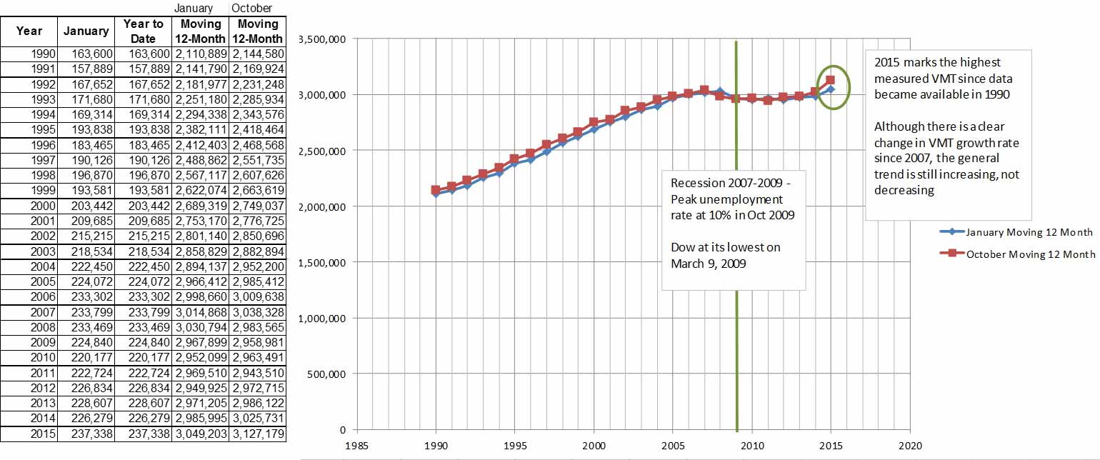
3.3. Are vehicle miles traveled (VMT) going down nationally? If so, would this decrease in traffic eventually make a boulevard a reasonable alternative?
VMT would have to decrease by more than 50% before a boulevard could be considered as a viable alternative. According to the national VMT data, VMT is at an all-time high. VMT per capita may be decreasing but both national and Little Rock populations are increasing, thus increasing VMT. According to Metroplan, the Little Rock metro area is expected to increase another 220,000 people by 2040, with 75% of the growth expected outside of Pulaski County. Current infrastructure challenges and congestion problems warrant immediate action and public meeting attendees have stressed that immediate action be taken now.
3.4. If vehicle miles traveled (VMT) declines, will I-30 still require increased capacity?
According to the FHWA, national VMT is at an all-time high (see table A below). In the November 2015 Traffic Volume Trends report (U.S. Department of Transportation’s Federal Highway Administration), there was a 2.9% increase in Arkansas VMT compared to November 2014. Previous month comparisons also reflected this increase in VMT.
Federal Highway Administration Traffic Volume Trends
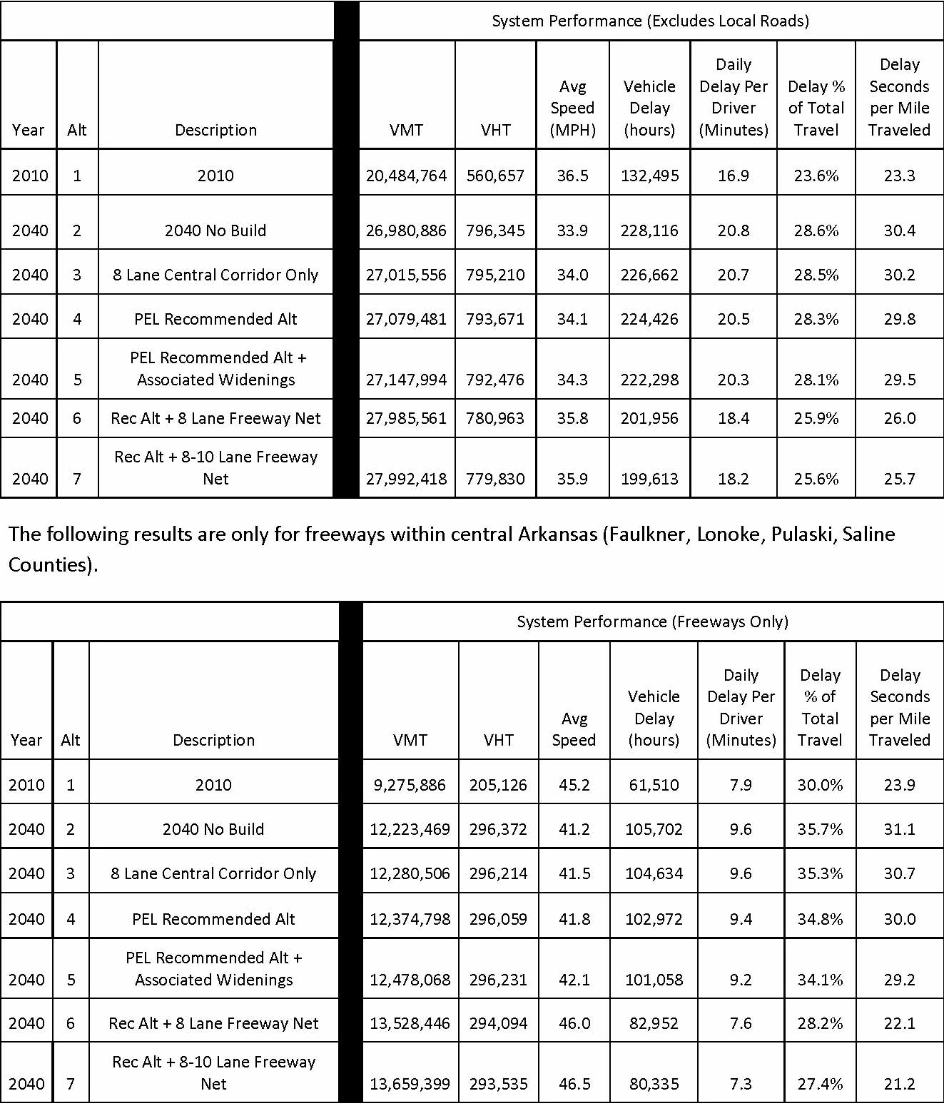
In addition, according to Metroplan, the Little Rock metro area is expected to increase by 220,000 people by 2040, with 75% of the growth expected outside of Pulaski County. Furthermore, Metroplan’s System Analysis says VMT will increase by more than 30% between 2010 and 2040, even if I-30 is not improved (see table B below).
A - National VMT
B - Current and Projected VMT from Metroplan’s 9/2015 CARTS Freeway Systems Analysis
3.5. If through traffic was diverted to I-440, could I-30 be converted into a boulevard?
Traffic is already being diverted to I-440. There are several ways through traffic is alerted that I-440 is a downtown bypass route.
1. Signage on I-40 westbound directs drivers to take exit 159, interstate I-440, to go to Texarkana. 2. Signage on I-30 eastbound directs drivers to take exit 138A, interstate I-440, to go to Memphis. 3. Google Maps and other mapping software will often recommend that drivers moving through the area take I-440 to I-30 or I-40 because it is the current, shortest travel time.
Based on discussions with community leaders, truck drivers and review of truck data, truck traffic currently uses I-440 over I-30. Truck volumes are lower on I-30 (6% in 2014) than they are on I-440 (32% in 2014). Truck drivers avoid driving during peak congested time periods and congested corridors because time is so valuable to the delivery of goods. As a result, truck drivers try and avoid the I-30 corridor and use alternate routes such as I-430 and I-440 when possible.
According to Metroplan, I-30 through traffic is estimated to be less than 18% of total I-30 traffic in 2040 (I-30 PEL, Appendix F - 44mb). Due to the origin of the trips being taken, not all of this traffic will be willing to reroute to I-440, resulting in far less than 18% of traffic being diverted from I-30. This would leave the majority of the 2041 forecasted traffic still on the I-30 corridor attempting to use a 6-lane boulevard, which has a capacity that is less than 50% of the existing 6-lane freeway. Congestion on a boulevard would be higher than what is shown in the 6-lane freeway future No Action scenario. This congestion would be worsened still with the implementation of pedestrian light sequencing at the signalized interchanges.
Travel patterns on this corridor have been established over time as a result of how Little Rock and North Little Rock have developed. Dramatic changes in these traffic patterns cannot be made without significant impacts on businesses, housing patterns, and the general economic vitality of the region. In addition, significant improvements to other corridors and interchanges that would receive traffic diverted from I-30 would have to be made in conjunction with any downgrade in capacity of the I-30 facility.
3.6. What will happen to property owned by ArDOT that is no longer needed after the re-design of the Highway 10 Interchange with I-30?
The Department has a very stringent process for how excess property (right of way) is relinquished. If a parcel goes unused, this does not guarantee that the property will go to public auction or that the City of Little Rock will obtain ownership of those parcels. There are federal processes associated with releasing excess right of way that have to be followed; therefore, assumptions regarding any change in ownership and/or use of this right of way cannot be made at this time. The Arkansas Highway Commission is currently working with the City of Little Rock to determine how this property can be used for public purposes.
3.7. Have other studies been conducted regarding the need for widening I-30?
Yes. Central Arkansas Regional Transportation Study (CARTS) was commissioned by ArDOT and Metroplan in 2003 to conduct two Areawide Freeway Studies. The studies analyzed the Arkansas River crossings and regional freeway network for the 2025 design year. Traffic on I-30 was forecast to increase by 23% between 2001 and 2025. The reports concluded that I-30 warranted 10 lanes by 2025 to achieve peak period conditions that were not congested.
The study identified a new Arkansas River Crossing at Pike Avenue, but after further analysis concluded that the new river crossing would only divert a small number of daily vehicles from I-30. Since the completion of the Areawide Freeway Studies, development along the study corridor has made a new River crossing less feasible. The study also considered enhanced transit as an option for the corridor but concluded that even a robust transit system wouldn’t divert enough traffic to mitigate the need for regional highway improvements. In addition, for more than a decade Metroplan has reported serious to extreme congestion levels exist on I-30 and I-40 and recommended interchange improvements at I-30/I-630, I-40/I-30 and I-40/Highway 67. Although it was determined that a new river crossing and transit improvements would not provide adequate relief to the I-30 corridor, they do provide other regional mobility benefits for the region.
Even as recently as January 2011, Metroplan reported the need to widen I-30 and I-40 to 10 lanes from I-630 to Highway 67/167 as indicated in their Congestion Management Process Report. This was the same recommendation that was indicated in the 2003 CARTS Areawide Freeway Study.
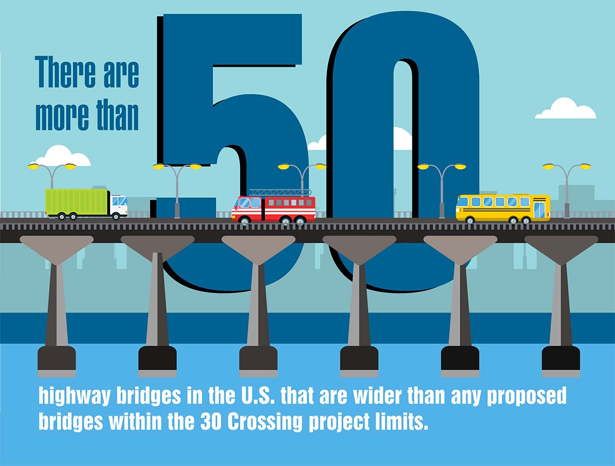
3.8. Will the new proposed Arkansas River Bridge be one of the widest in the nation?
According to the National Bridge Inventory Database provided by the Federal Highway Administration, there are at least 50 highway bridges in the United States that are wider than any of the proposed bridges within the 30 Crossing project limits, including the Arkansas River Bridge. None of the bridges in the proposed project would be considered one of the widest in the country.
4. Public Involvement
4.1. How has the public been involved in developing the project’s purpose and need?
The Federal Highway Administration (FHWA) has authority on all state highway projects and has determined a need for this project. FHWA delegated authority to the Study Team (ArDOT and consultants), and the Study Team has provided opportunities for the public to be involved through every step of project development. Project Partners (City of North Little Rock, City of Little Rock, Pulaski County, Metroplan, FHWA, and ArDOT), Technical Work Group (TWG) members, stakeholders, and community members were involved in all phases of the project from conception to present. Furthermore, TWG meetings brought representatives together from more than 30 federal, state and local agencies to gather technical expertise utilized throughout the PEL process.
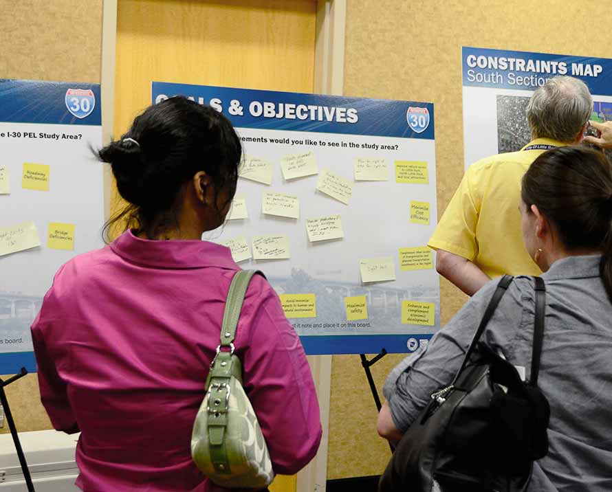
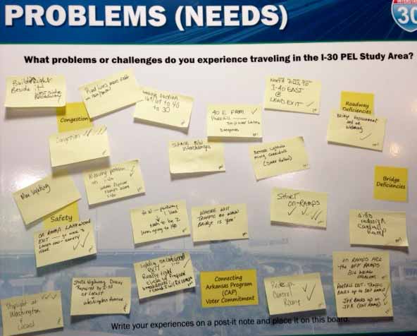
Public input was solicited at the first set of public meetings for the I-30 PEL study which took place on August 12, 2014 in North Little Rock and August 14, 2014 in Little Rock. Both meetings included a station that displayed two interactive exhibit boards, one titled "Problems (Needs)" that asked attendees to list what problems or challenges they experience when traveling in the study area; and one titled "Goals and Objectives" that inquired what improvements they would like to see in the study area. Members of the Study Team were stationed at these interactive boards and used Post-It notes to transcribe problems and goals identified by public meeting attendees. The Post-It notes were attached to the respective exhibit boards for all meeting attendees to view. More than 400 comments were received, and these public comments are documented in the Public Meeting #1 Summary and Analysis Report (27.5mb).
See images below of public meeting station.
Many of the problems and study goals were identified mutually by agencies, the public and the Study Team. Additionally, input from Project Partners, agencies and the public resulted in the addition of several goals and/or guiding principles of the study. These included improving the opportunity for east-west connectivity; avoiding and/or minimizing impacts to historic and archeological resources; minimizing the real, perceived and visual barrier of the freeway; and ensuring an open public participation process.
In summary, public and agency input guided the identification of problems before they were established in the study objectives, goals and Purpose and Need. Documentation of the development of the Purpose and Need can be downloaded here.
4.2 How much public involvement has been performed throughout the project?
The Department appreciates the public and agency involvement throughout the process. In a two-year period beginning April 2014, more than 1,500 attendees have participated in 6 public meetings and submitted more than 2,200 questions and comments.
5. Funding
5.1. How will the proposed 30 Crossing project be funded?
Click here to see the funding sources for the 30 Crossing project. The funding sources for the project are outlined above. Percentages are based on an estimated $631.7 million budget. The Arkansas Department of Transportation’s constitutional authority is primarily limited to the construction and maintenance of highways. Authority relating to transit and other modes of transportation is restricted to the planning phase, with no authority to provide funding for implementation or operations.
5.2. Will widening I-30 require all connecting freeways to be reconstructed at an estimated cost of $4 billion?
The $4 billion estimate was not developed by the Department. This estimate was produced by Metroplan based on assumptions that ArDOT has reviewed and determined to be inconsistent with the Department’s standard planning processes. Metroplan developed this estimate on the theory that if the Department’s planning process results in a recommendation to widen I-30, then the same result would apply to every interstate in the region, resulting in their widening to 8 or 10 lanes.
Prior to improving a highway facility, the Department performs a planning study of the corridor and a project-specific environmental study to determine the best methods for mitigating any current and future deficiencies on the corridor. These studies look at many factors, such as safety, congestion, cost, and environmental impacts to determine what methods of improvement are most feasible. Each corridor poses different constraints and challenges, which can result in different planning recommendations coming out of the corridor-specific studies.
For example, the property owned by the Department in the 30 Crossing corridor provides ample room for widening without requiring expensive and environmentally challenging purchases of additional property. This corridor feature makes widening a viable option for recommended improvements. This is not the case in every corridor, and a study in an area with less available property or other similar constraints could result in a recommendation other than widening, which is why any specific changes, including widening, should not be assumed prior to completing a specific corridor study.
Other than the Planning and Environmental Linkages (PEL) Study on the 30 Crossing corridor, the Department has not recently completed a study on any freeway in the Central Arkansas area. As a result, any claim that widening I-30 will require widening elsewhere in the Central Arkansas freeway system is inaccurate and presupposes the results of future planning or environmental studies on the system’s freeways.
Additionally, Metroplan’s Systems Analysis shows that improving the 30 Crossing corridor results in a freeway system that performs better than it would if no improvements are made to the corridor. This clearly shows that any calculation of future costs for system improvements cannot and should not be attributed solely to the 30 Crossing project. A number of the improvements recommended in the Systems Analysis would be warranted regardless of whether or not the I-30 improvements are constructed. Regional transportation improvements are primarily needed as a result of the 220,000 population increase projected by Metroplan in the recent Imagine Central Arkansas report.
The PEL Study for the 30 Crossing project did identify two areas adjacent to but outside the limits of the project that will need to be studied for future improvement. The Department either has studies underway or planned for these two areas, and these studies will determine the most feasible method for mitigating any safety or congestion issues in the corridor. The areas identified in the PEL are:
- I-30 between the south terminal and 65th Street
- I-630 westbound from I-30 past Louisiana Street
It is also important to note that these studies are not being performed as a result of the 30 Crossing project but were already planned or in progress due to existing deficiencies in the corridors.
6. Schedule
6.1. Once an alternative is chosen for 30 Crossing, when will construction begin and end?
The current schedule for the 30 Crossing project has the Department entering into a contract with a Design-Build team in the summer of 2017. Because 30 Crossing is a Design-Build project, the Design-Build team will have to design the project before construction can begin. With this design work occurring in late 2017 and early 2018, construction is not anticipated to begin on the 30 Crossing project until mid-2018 and is estimated to be open to traffic sometime in 2022.
6.2. Will the Broadway bridge be opened before the 30 Crossing project begins?
Yes. Because 30 Crossing is a Design-Build project, the Design-Build team will have to design the project before construction can begin. Construction is not anticipated to begin on the 30 Crossing project until after the opening of the Broadway bridge. If at any time schedule changes result in the Broadway bridge still being closed when the 30 Crossing project is ready for construction, the Department will delay construction on any portion of the 30 Crossing project that impacts traffic until after the Broadway bridge is open to traffic.
7. Transit
7.1. Does ArDOT have the authority to fund public transit on its projects?
The Department's authority in relation to transit is primarily limited to assisting in the transit planning process, with no authority to provide funding for transit implementation or operations. In addition, funds allocated to the Department through the Connecting Arkansas Program half-cent sales tax are not intended for transit improvements but for widening and improving the state's highway system.
ArDOT has worked with Rock Region Metro on the 30 Crossing project to identify ways to accommodate transit in the corridor, and Rock Region Metro serves as a member of the 30 Crossing Technical Work Group.
7.2. Can transit improvements help decrease existing and future congestion on I-30?
As part of ArDOT's I-30 Planning and Environmental Linkages (PEL) study, the project team developed conceptual estimates of transit ridership and costs for an express transit system to test the potential of reducing traffic volumes on I-30 and other freeways in the Little Rock area. The concept included two scenarios:
- A baseline transit system with 30-minute service frequencies
- An enhanced transit service with 10-minute service frequencies
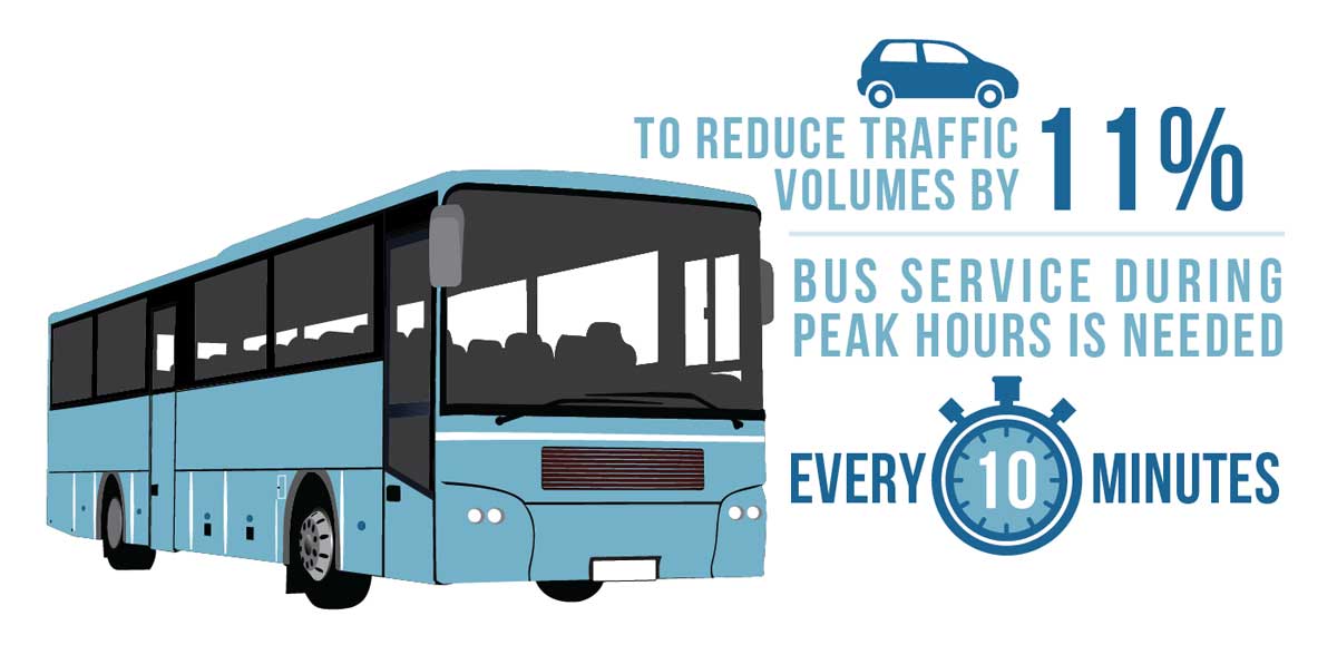
The concept included seven express routes serving different parts of the metro area, including four that would affect traffic on the I-30 river crossing. The I-30 PEL study concluded that peak hour traffic volumes on the I-30 river crossing could be reduced by up to 11% with maximum transit investment in the corridor; however this reduction was not sufficient to achieve an acceptable reduction in congestion in the design year for A.M. and P.M. peak hours.
In order to achieve this reduction in traffic volumes of up to 11%, enhanced 10-minute headway (the frequency of bus service) express service is needed during peak hours. The recently proposed 2016 Pulaski County transit tax initiative was to provide service frequencies on "important routes" of 15, 20, 45 and 60 minutes (stated as longer term investments); there was no mention of 10-minute frequencies. Therefore, an even greater investment than that proposed in the transit tax initiative would be necessary to achieve the best case transit scenario of removing 11% of traffic off of the corridor.
So, while an increase in bus service could remove some traffic from the 30 Crossing corridor, the amount of traffic removed from the corridor in the best case scenario is not sufficient to remove the need to increase capacity in the corridor.
7.3. Has light rail transportation been considered? If so, would it reduce congestion in the corridor?
The Areawide Freeway Study (2003), a study jointly funded by the Department and Metroplan, evaluated the impact of implementing light rail between Little Rock/North Little Rock and Cabot and Conway. The results of that study showed having light rail transportation would only reduce vehicular traffic on all river crossings by 3%.
In addition, as part of the I-30 Planning and Environmental Linkages (PEL) study, which was completed in 2015, both light rail (street car) and commuter rail were identified as alternatives and studied.
Light Rail (Street Car) – The Rock Region Metro (RRM) (formerly known as the Central Arkansas Transit Authority) Strategic Plan (10-year plan) does not include light rail improvements. Light rail is part of RRM's long range plan; however, RRM has indicated that they would implement Bus Rapid Transit (BRT) before implementing light rail along future light rail corridors. This alternative was screened out in the PEL study as a result of RRM not including light rail in their 10-year Strategic Plan and the lack of a dedicated funding source identified in the Metroplan Long Range Metropolitan Transportation Plan.
Metroplan modeled light rail under the category of Fixed Guideway, which included both light rail and commuter rail, and found that together under the most aggressive "Supportive" land use policy, fixed guideway attracts approximately 6,400 person trips which represents less than 3% of the total trips in the corridor.
Commuter Rail – The Rock Region Metro Strategic Plan (10-year plan) does not include commuter rail, nor is it included in RRM's long range plan.
Click here to learn why funding for this project cannot be used to fund Light Rail or Commuter Rail.
